5-6 Days | 64.3km | Expert Route | West Coast
I have dreamt about going to Ivory Lake ever since i first heard of the place four years ago - I am easily inspired by a good photo or two! At the time, it was some way above my skillset and ability level and so it remained a dream, but one that quietly motivated me in the background to learn more, try more and get out to meet people that could help me realise this dream. Having ventured out onto more technical terrain over the years, upskilling myself around navigation, route finding skills and river crossings, I was starting to get to the point of feeling like this was an achievable task. But not alone! The final tick in the box came after joining my local tramping club for some snowcraft courses. Not only did I meet people more skilled and able than me (that I happened to get on with really well), I also discovered there was a trip planned to this very hut. A mere 8 months later and I found myself jumping on a plane, ready to go!
As much as preparation and being capable plays a large role in being able to get to Ivory Lake, you also need an element of luck. With it being a 6-day trip and living up in the North Island, the ability to be flexible on trip dates isn’t really there, so we needed the weather God’s to be on our side….and they were. Six days on the West Coast and not a single day of rain. Unheard of!! Not only that, but the days before had also been pretty dry which meant the river levels were relatively low, again a massive help on this trip.
Day 1 - Moonbeam Hut
17.8km | 10hrs | 1000m Ascent | 633m Descent
Our research into this particular route to Ivory Lake had told us that the first two days would be big days, so we were expecting it. It was a pleasant surprise for me therefore that the first couple of hours of the day were pretty easy going. Walking along the riverbed, crossing it 4-5 times and skirting the edges of farmland until we reached the first ascent was an enjoyable way to start….but not an indication of how it was to continue. We certainly profited from the low river levels here – you could see that in places the river level only needed to be slightly raised to require a big bush bash to get around certain points, so you just don’t know what to expect until you get there.
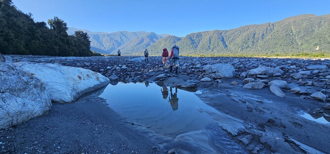
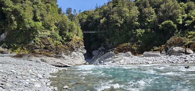
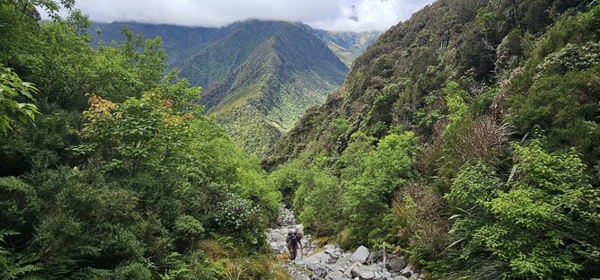
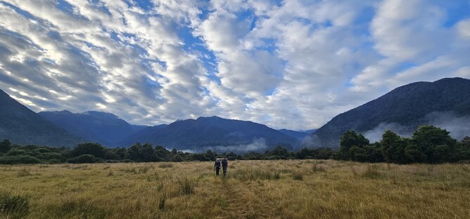
After around two hours of travel along the river, we headed into the bush and ascended pretty steeply almost immediately up towards a ladder that helped with the push to the top of the ridge. About 10 minutes after the ladder there is a beautiful view at an opening in the trees, so we stopped for a morning tea break here (photo below). From here we stayed in the bush for another hour or so on undulating track before we reached another steep ascent. We climbed for approximately an hour before reaching the swing bridge that crosses a beautiful turquoise water filled gorge. Across the riverbed and into the distance you could catch a glimpse of Kiwi Flat Hut (if you knew what you were looking for) and that is where we were headed for a lunch stop. Dropping back down onto the riverbed and following it to the bush line, we crossed the river and headed up to the Hut. A great spot for a good break and if you were just looking for a weekend away this would be a good destination in itself. This is a 6 Bunk Standard Hut and there is a long drop toilet at the hut.
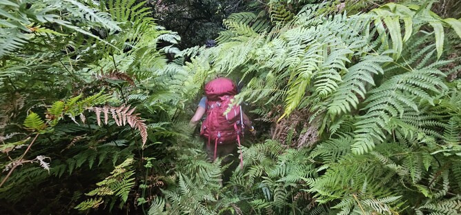
From Kiwi Flat Hut it was straight back into it with a sharp climb immediately from the Hut until reaching the top of the next ridge (are you sensing a theme yet?) and travelling along the ridge for a while. At the Junction with the Spur track we dropped steeply down hill back towards the main river with what felt like a very long sidle along the side of the ridge (over 2 hours). It wasn’t particularly easy going, with a fair amount of fallen trees to navigate around and thick scrub to get through at times, but the track was still easy enough to follow at this point, albeit there are a fair few sections where there are steep drops beside you to negotiate as you pick your way along the shrubs that provide some foot holds.
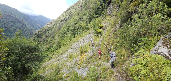
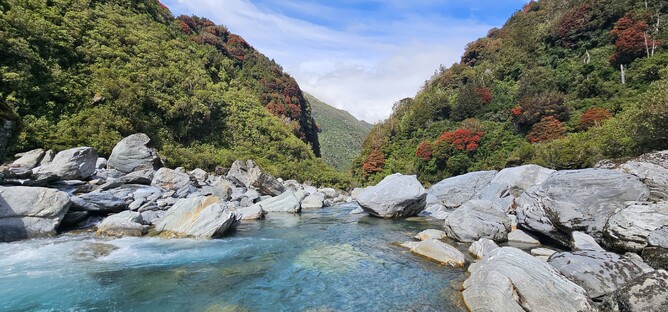
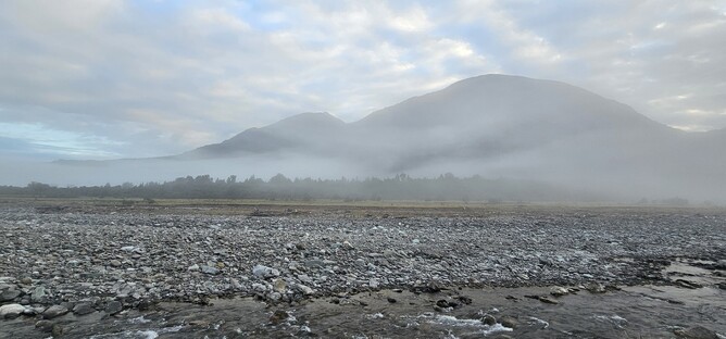
On approach to the river we were greeted with stunning glimpses of the bright blue, crystal clear water of the Waitaha River surrounded by beautiful grey rocks and surrounded on either side with dense Rata lined bush. After the long sidle along the ridge it was a nice step change to be rock hopping and I felt like we were making really quick progress along the river. Again, we were lucky with the river level as at times we were able to pick our way round large boulders in the water as the flow was slow enough and below waist height. Only three times did we have to bush bash our way up the banks and around double decker bus sized boulders that blocked our progress up the river bank.
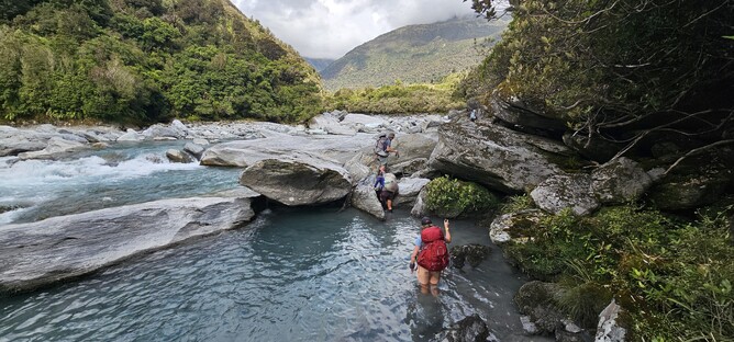
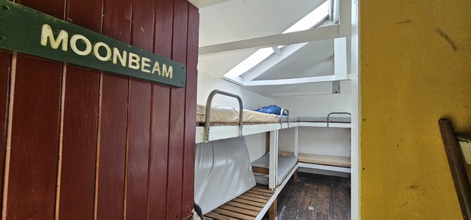
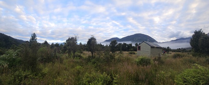
After a couple more hours we reached a point where we were level with the hut and found the little marker indicating that we were to head back into the bush. It was a steep 10 minute climb up to Moonbeam Hut and worth noting that there is no access to a stream/river at the hut so if you want to swim then you either need to make the walk back down or go before you head up! Moonbeam Hut is a 6 bunk standard hut with a long drop toilet and water tank, it was a welcome sight after a 10 hour day and beautiful spot nestled in the bush to watch the sun go down.
Day 2 - Top Waitaha Hut
12.5hrs | 11km | 1030m Ascent | 446m Descent
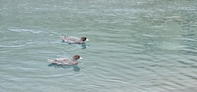
Day two started much like day one had ended, with a short, sharp uphill into the thick native bush, before then returning back down on the other side of the ridge to meet the river. It took around 30 minutes to reach the river and much to my delight, we were greeted by two Whio chilling out on the river. In over five years of being here, it was my first experience of seeing the rare Blue Duck, despite so many attempts to find them on my adventures. As it turned out, this wouldn't be the only sighting this trip - in fact we went on to see Whio nearly every day we were there which was pretty special!
Once at the river we set off on our boulder hopping mission again to make progress through the valley. It was relatively easy travel for the next hour or so, with the odd deeper section of river to negotiate, or short bush bash over and around a large boulder.
This is where my more experienced friends definitely saved us a fair amount of time, by finding even the most hidden of routes up into the bush and around boulders that I wouldn't have even thought to look for. All a learning experience and one I will hold with me for future trips.
After an hour we came to the next big climb up through the forest. We needed to get up and down the ridge in front of us so that we could drop down to the Waitaha river bed which would eventually lead us up to Top Waitaha Hut. Being a very hot and humid day, any ascent felt quite tough and this one was no exception. But in terms of what was to come that day it was a pretty nice track to follow, just a bit steep.
As we reached the ridge and travelled along it, we came up into the Rata canopy. The stunning bright red flowers capturing the sunlight and shading the surrounding ridges with a beautiful red tint. Through the trees we could see the Waitaha river, our destination. Didn't look too bad from this angle, but I guess it never does until you get up close! Just before dropping down to the steep downhill section we took a little break to enjoy the breeze and shade. We were making good time, so still plenty of light left for the afternoon of river travel that was to come.
The descent took around 40 minutes. At the bottom of the hill we crossed a tributary river and then continued on through to the Waitaha. As we broke through the final section of bush and out on to the banks we were met with a beautiful sight of turquise water cascading down impressive grey rocks with a backdrop of red Rata forest in all directions. The camera just couldn't capture what we saw that day - it was one of those "you have to see it to believe it moments" that will be forever etched in my memory.
As we sat by the river eating lunch we checked our maps and realised we were only 3km away from the hut. Great news I thought to myself quietly. We have been prepared for this to be a 14 hour day, but 5.5 hours in and we only had 3km to go, so we must have been speeding along......or so I thought!
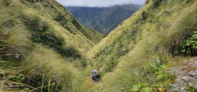
The next 3km took us over six hours. Fortunately I didn't look at my watch during this time otherwise I think I would have been very demoralised, but its fair to say it was slow going. After around 6-7 steep bush bashing expeditions up the side of the ridge to get round double decker bus sized boulders in the river, we eventually got to a point where there was a tussock laiden hillside next to us on the true right of the river. We chose to leave the river bank and cross the tussocks instead. Not sure if this was harder or easier than what we had just done, but at least it was different.
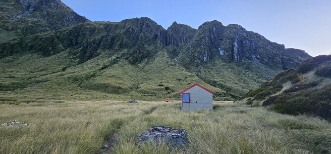
Once we were far enough along the river we dropped back down to the river and crossed over. After a little more boulder hopping, we headed up the bank on the opposite side of the river onto the tussocks where we could see the hut in the distance. It felt like it took forever from here to actually reach the hut, though in reality it was around 30 minutes of pushing through the tussock grass and ploughing through the little creeks that littered the path in front of us. After 12.5 hours of being on the move, we had made it. This was a six bunk standard hut, with no water tank but easy access to the river (approx. 30m away). There was a long drop here, the last for this trip until the final night!
Day 3 - Ivory Lake Hut
5.8km | 3hr 45min | 443m Ascent | 121m Descent
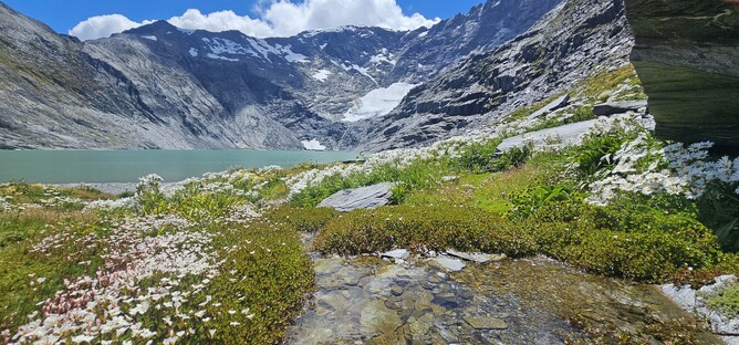
We woke to the most beautiful clear morning at Top Waitaha Hut. When leaving civilisation the weather forecast for this day hadn't been great, but again, the weather God's were being kind to us. We were all really excited about this day, not only to reach the hut we were aiming for, but also the fact it was due to be a short day so once we were there we would actually be able to enjoy it.
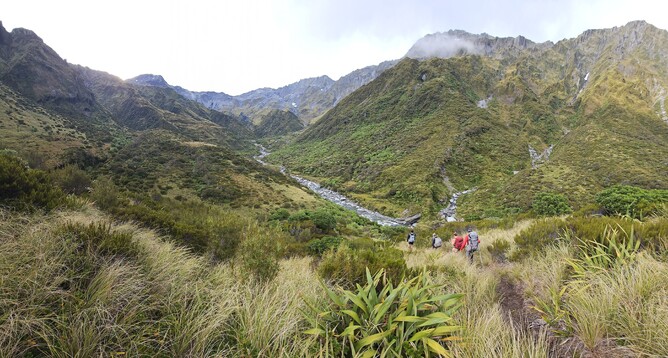
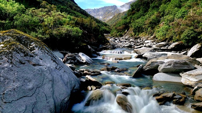
We set off reasonably early, with the sun still making its way up above the mountains that now surrounded us. The start of the day was walking along the river. An easy walk with small stones, rather than any boulders and a very shallow river beside us. We followed the river along for around 20 minutes until we reached the confluence with Stag Creek. Here we crossed and headed up onto the terraces in front of us. We did take a little detour across to the true right of the river to check if that was the route, but decided that we were right the first time so returned to this spot and whether it was right or wrong, we certainly found an easy enough route through.
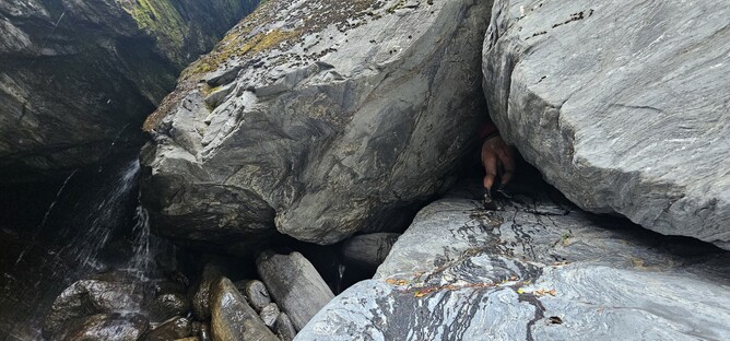
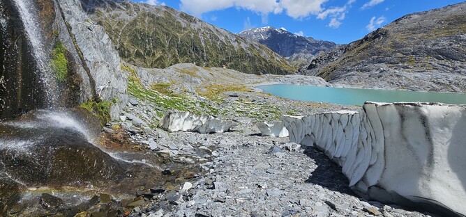
We made our way up to the tops from the terraces, where we were met with some beautiful tarns that reflected the mountains in the now bright sunshine. For around 30 minutes we headed across the tops before dropping back down to the true left of the Ivory Lake outlet, we made our way steadily towards the point where the river and terraces met before picking our way down the steep grassy bank to the river bank. We remained on the true left of the river all the way to the enormous waterfall that marks the start of the last ascent up to Ivory Lake.
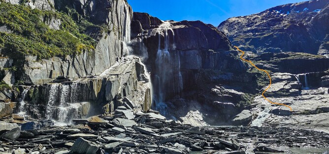
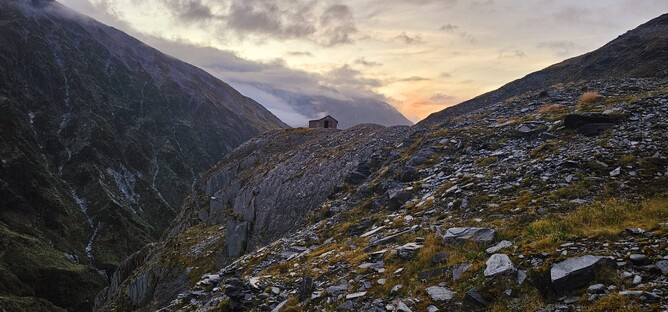
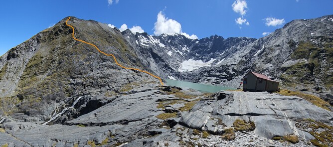
If I am honest, this waterfall (or pictures of it) were my main motivator for visiting Ivory Lake. It is so impressive and my photo's do it no justice at all. I could have stayed for hours, but not sure the rest of my group was all that keen, so on we went. Crossing the river towards the waterfall and then climbing up the rock between the two larger waterfalls (pictured above) we made our way to another grassy section where we were able to ascend up to more terraces on the left. We stuck towards the left and made our way up and over the knob in front of us which was hiding Ivory Lake. After around 20 minutes, the lake and then the hut finally came in to view. Stunning!
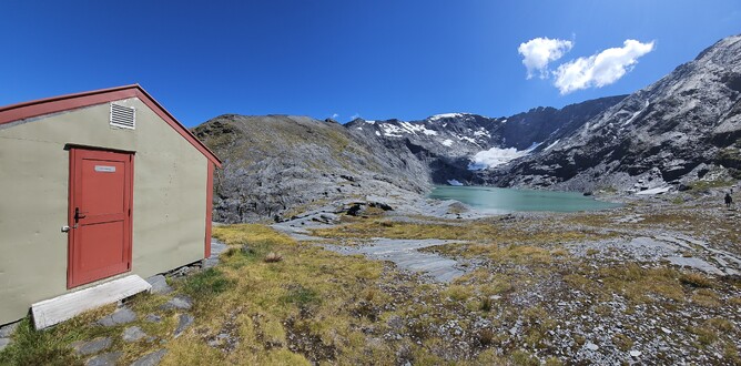
The Hut and the famous red chair are well documented and exactly as you expect them to be. If anything the hut was bigger than I had imagined it to be, with a separate little workroom tagged on to the main hut. There is no long drop and there is a pack out policy here, so make full use of the facilities at Top Waitaha if that doesn't appeal! Water was readily available from the waterfall a short walk away from the hut. We arrived at lunch time and were able to just relax and take in the incredible surroundings the rest of the day which was awesome.
Day 4 - Top Tuke Hut
12.5km | 8hr 45 min | 1140m Ascent | 1508m Descent
Sometimes the return from a Hut can be a bit of an anti-climax and you are almost willing the trip to end. Not on this trail however! The trip out was via a different route and was equally spectacular as the way in, if not more.
We departed the hut at around 6.30am, knowing that we had a long day ahead of us. Our intentions were to head out along the ridge we had looked at all of the previous afternoon from the hut, cut round the back to point 2084 and then over the Mt Beaumont, before descending back down the valley behind towards Top Tuke Hut. The descriptions of the route from those that had gone before made it very clear that this would be the most technical part of the whole trip and good conditions really were essential. Fortunately we woke up to a beautifully clear morning once again, so we departed with confidence that we would be able to get over the higher sections safely.
From the hut we headed towards the ridgeline on the left of the lake, crossing the outlet stream and then almost immediately starting the ascent. The terrain, whilst steep, had good grip and was easier to travel up than I had thought it would be when looking at it from the bottom. Occasionally there would be particularly steep sections that involved scrambling up, but there were fairly good hand holds, albeit the rock at times was quite crumbly and fell away. I didn't feel uneasy at any point here, but if you are nervous around heights, then this would be a tough route to follow as there are numerous exposed sections.
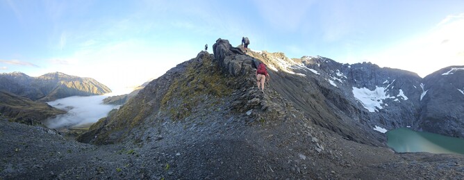
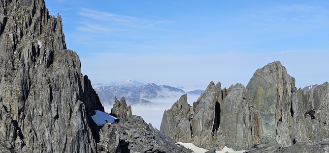
Once up at the first minor peak, we sidled round the back of the next peak ahead of us towards Point 2084. This is the one that is highlighted as being particularly tricky, so we approached with a little apprehension, picking our way along the rocky sections between patches of snow to find a route offering good grip. Having dropped behind the Ivory Lake Glacier, we now had a new world of mountains opening up to the other side and incredible basins of rocks below us - it truly is a special place, and as much as we had to concentrate on where we were going, it was also a journey to savour. Afterall, how many times are you ever going to be here?! Having made it up to a little plateau, we took a short break before dropping down towards the rope section that numerous trip reports mention.
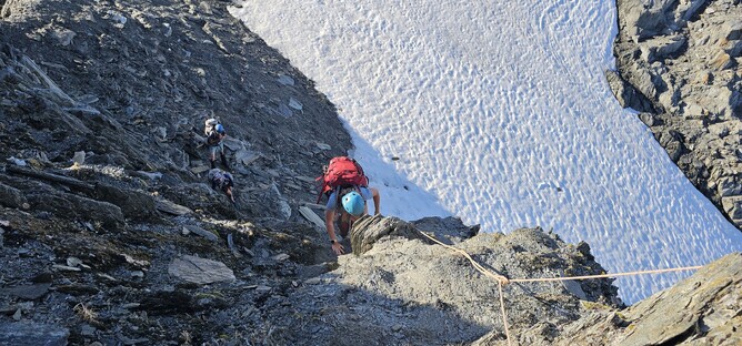
Sending one of the better climbers up the rope first to test it, we were confident in its condition and the climb itself was also relatively straightforward (and short!), so no more of a challenge than the steeper sections of the initial ascent that day. However, coming down that section, you certainly would be grateful for the rope and in wet conditions it would be a completely different story, so I was pretty happy that we got through in the stunning weather that we had.
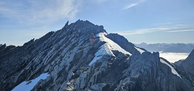
At the top of the rope, the view got even more spectacular. With the clouds from the valley now starting to rise, we could look in any direction and feel like we were standing on a cloud, with big spikes of rock piercing the cloud layer. We continued along the ridge before starting to descend to the saddle that we could see ahead of us, which was heading towards Mt Beaumont. The most technical parts of the trip were now behind us, so we stopped at the saddle for a little snack break ahead of the ascent to Mt Beaumont. It isn't strictly necessary to head up to the summit, but on a beautiful day, it would have been a massive missed opportunity not to go up, so there wasn't really a decision to make!
Mt Beaumont was still covered in snow, but it was soft enough to walk up without needing crampons. As we started to get towards the summit, the cloud overtook us and we arrived to find ourselves standing in a layer of cloud. We had made really good time, so instead of pushing on, we chose to stay up here a while longer and have some lunch to allow the cloud to pass. It never fully cleared, but we did have patches of clear sky so got some great views one direction at a time. We also discovered that there was pretty good phone signal up here, so were able to do a good weather check and get any updates.
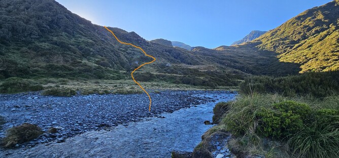
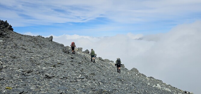
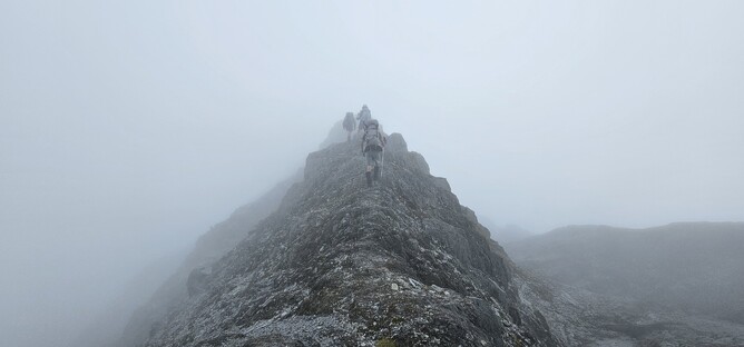
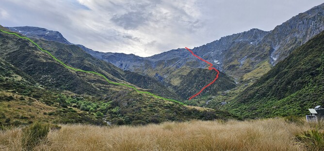
From the Mt Beaumont Summit, we headed back towards Point 2130 before following the ridge back down into the basin behind. With the clouds rolling through and only occasionally revealing the mountain tops now, it made for an atmospheric walk. As we descended, the grey rock turned to scree in sections, but was relatively easy going. As we met the head of the stream, we stopped for another drink break and to orientate ourselves again. There are a few different route options here and finding the right ridge to follow (especially in low cloud) was not the easiest of tasks. We ended up retracing our steps a couple of times, having tested a route and deciding that we weren't right.
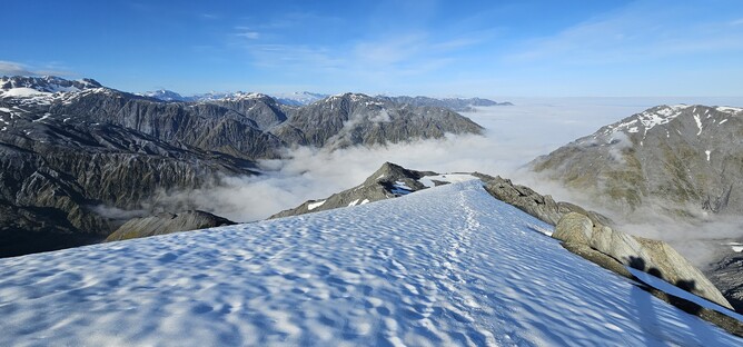
The photo below was taken the next morning, once the skies had cleared and shows the ridge that we ended up following. There are other route descriptions that followed routes to either side of this ridge, but they didn't look quite as appealing from the top (or the bottom), so we were glad to have found this one.
As we dropped from the more open, rocky ridge into the tussocks, we discovered poles marking the way back down to the river. We could see the hut in the distance, but as with previous hut sightings - seeing the hut doesn't always mean you are almost there! Slowly but surely we descended to the river, which we followed for approximately ten minutes. We crossed twice to find a better route and then headed up to the true right on a marked path towards the Hut.
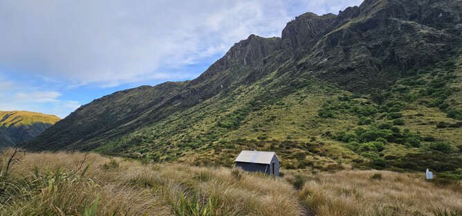
Once leaving the river bank it is only a short 5-10 minute walk up to Top Tuke Hut, a 6 Bunk hut with no long drop and no water tank. There is a water source relatively close to the hut which is described in the hut book.
Day 5 - Mikonui flat Hut
13.8km | 10hrs | 788m Ascent | 1620m Descent
The plan for Day 5 had been to travel around 6 hours to Dickie Spur Hut. As it happened, we made such good progress that we decided to push on to Mikonui Hut so that is what I will describe below. If doing it again, I would probably opt to stay at Dickie Spur or walk all the way out - we live and learn!
From the Hut we retraced our steps back down to the river before heading downstream and following the path of the river for approximately 3 hours. Compared to previous river routes, this one was pretty plan sailing and only required a couple of excursions off into the bush to remain on track. We stopped for morning tea just before we were due to start ascending the creek. Where we sat there was a beautiful canyon carved into the rock and a good swim hole, which some members of the group took advantage of.
The next 90 minutes were dedicated to a 500m ascent of the creek. At times slippery and narrow, it was actually quite a fun part of the day trying to work out the best way through and finally pushing up into the thick grassy tussocks to try and push our way back out on to the tops. Once there, the rest of the day was all about going down....and further down (much to the horror of my knees!).
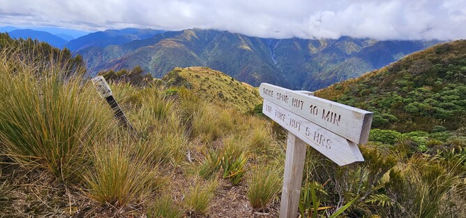
Upon reaching the ridge line we were able to follow this for around 20 minutes before dropping back down towards Dickie Spur Hut. The track was now marked, though some of the markers were quite far apart of hard to spot, so in poor visibility it wouldn't be an easy track to follow. We arrived at the turn off to Dickie Spur Hut just after lunch and at this point made the decision to commit to continuing on. The whole group was feeling good and we knew we would be able to reach the hut in daylight, so after a stop for lunch we pushed on.
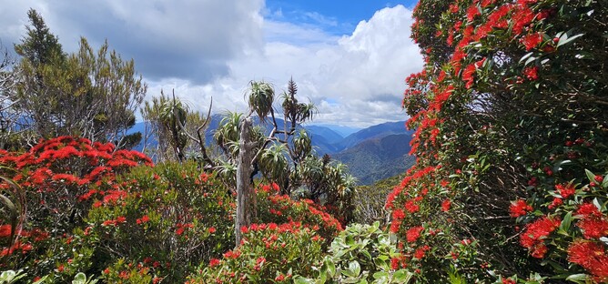
Not only did we luck out in terms of the weather on this trip, but we were also blessed with timing our visit with an incredible Rata blossom. Everywhere you looked the valleys were tinged with red - it was so beautiful that it was hard to concentrate on where you were walking!
My main recollection of the 5 hours from the turn off to Dickie Spur and arriving at Mikonui Flat Hut was that it was near constant downhill. It was relentless! For four hours we made our way down a path that was now pretty well formed and well marked, with varying degrees of steepness. After a short section following the river, we then ducked back into the bush and climbed up to find the wire bridge marked on the maps. This was the final bridge of the journey and crossed a beautiful little gorge.
From here we had another hour of climbing over the little ridge in front of us. It was only a 100m ascent and then a little drop on the other side, but at the end of a long day of descending the hut couldn't come soon enough! Finally, after around 10 hours of walking we saw it and were able to settle in for the night. Mikonui Flat Hut is a standard 6 bunk hut, popular with hunters. Unfortunately for us, it is also incredibly popular with the local sandfly population and we spent a hot, sticky night in our sleeping bags trying to shield ourselves from being eaten alive. Not quite the night we thought we might have to celebrate an amazing trip. All part of the experience I guess!
Day 6 - Totara valley Road End
3.4km | 1hr | 28m Ascent | 64m Descent
The last day, can almost not really be counted as a last day, but the story has to end somewhere! We walked for a total of one hour from Mikonui Flat Hut out to the Totara Valley Road End. This would definitely be do-able as part of the day before if you had somewhere nearby to stay for the night. A long drive would definitely not be a good idea.
We had a short walk from the hut out to the river bed which we were able to cross with ease. We had set off early, having not slept much the night before, so the sun was still rising at this point and burning off the mist.
On the other side of the river, you are mainly passing through farmland with more and more hints of civilisation starting the emerge. The historic homestead below, marked on the maps, made for a nice sightseeing tour as we meandered our way back towards the car.

After one final (shallow) stream crossing, we made it back to the main pathway to the car park. We had two cars in the group so had left one at the track end, which made for easy logistics on the way home and after an epic 5 day adventure we were all ready for a good coffee and breakfast in town.
Having read up about Ivory Lake for so many years and being so keen to get there, it was awesome to have made it. My favourite activity in the huts each night was reading other people's entries and that made it incredibly clear, that not everyone was as lucky as we were. Much more experienced trampers/climbers were noting that they had to turn back as conditions didn't allow them to progress, even after days of trying - so its a reminder that not only do you have to be well equipped and skilled to deal with the demands of the trip, you also need luck on your side. For experienced trampers, this is an exceptional trip and I would highly recommend it - but don't underestimate the preparation required to enjoy it safely.